Discuss a project
Menu

Marine Awareness · inland vessel operations

Close to the quay.
Clearer on what’s nearby.

When your vessel is alongside a quay, entering a lock or working near structures, judging what is close can be difficult. Marine Awareness is being developed to bring the camera view, nearby surface measurements and object information together for the operator.

For inland vessel operators, fleet owners, survey teams and remote-operation providers — onboard or ashore.

Available to demonstrateWorking indoor prototype · vessel validation next

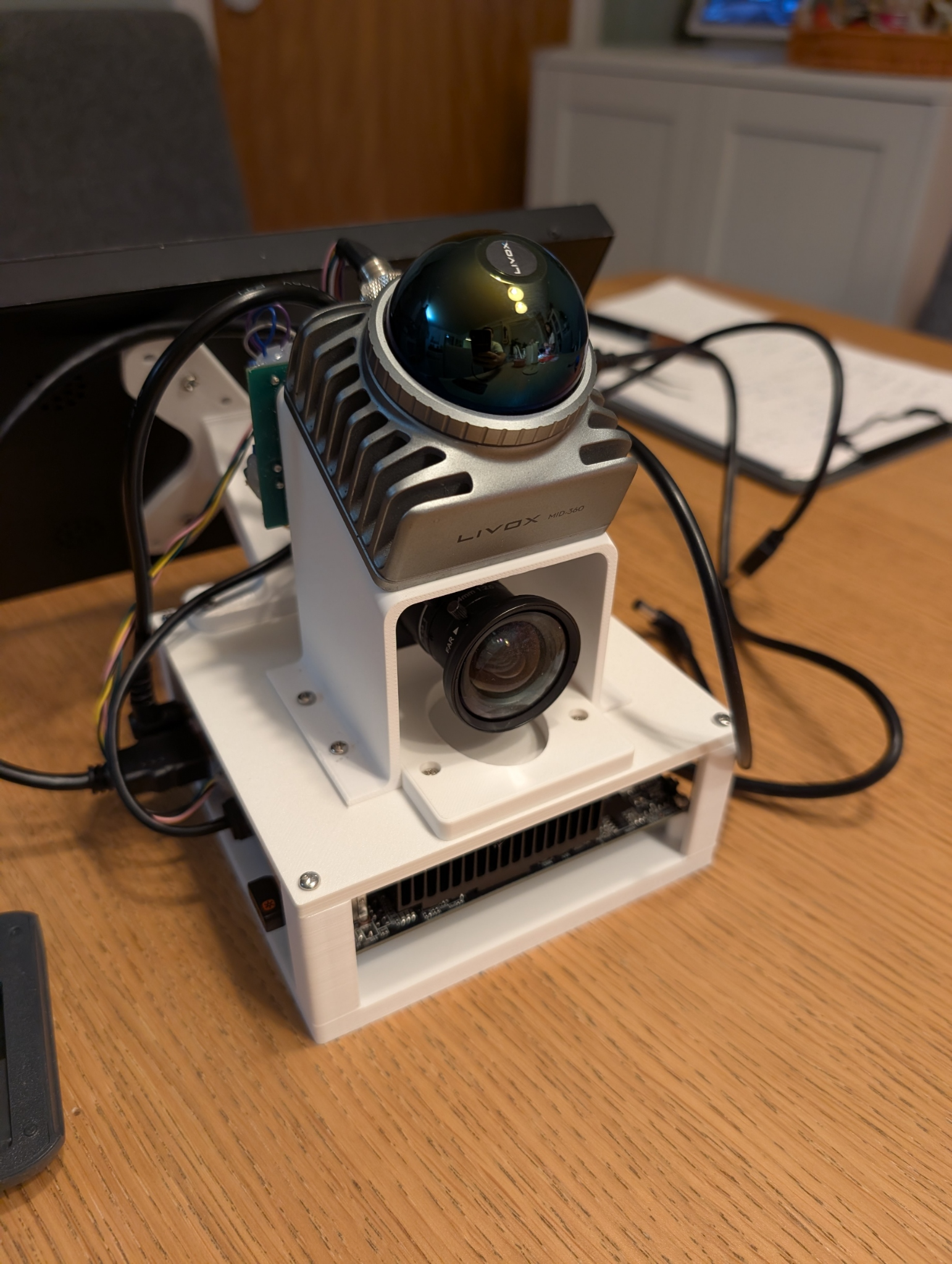
The actual Marine Awareness prototype, with a Livox MID-360 above a forward camera and compact computer
The actual prototypeLiDAR, camera and onboard computing assembled for indoor development and integration tests.
During a close manoeuvreSee the relevant surroundings
Alongside the camera viewAdd distance context
After the testReview what happened
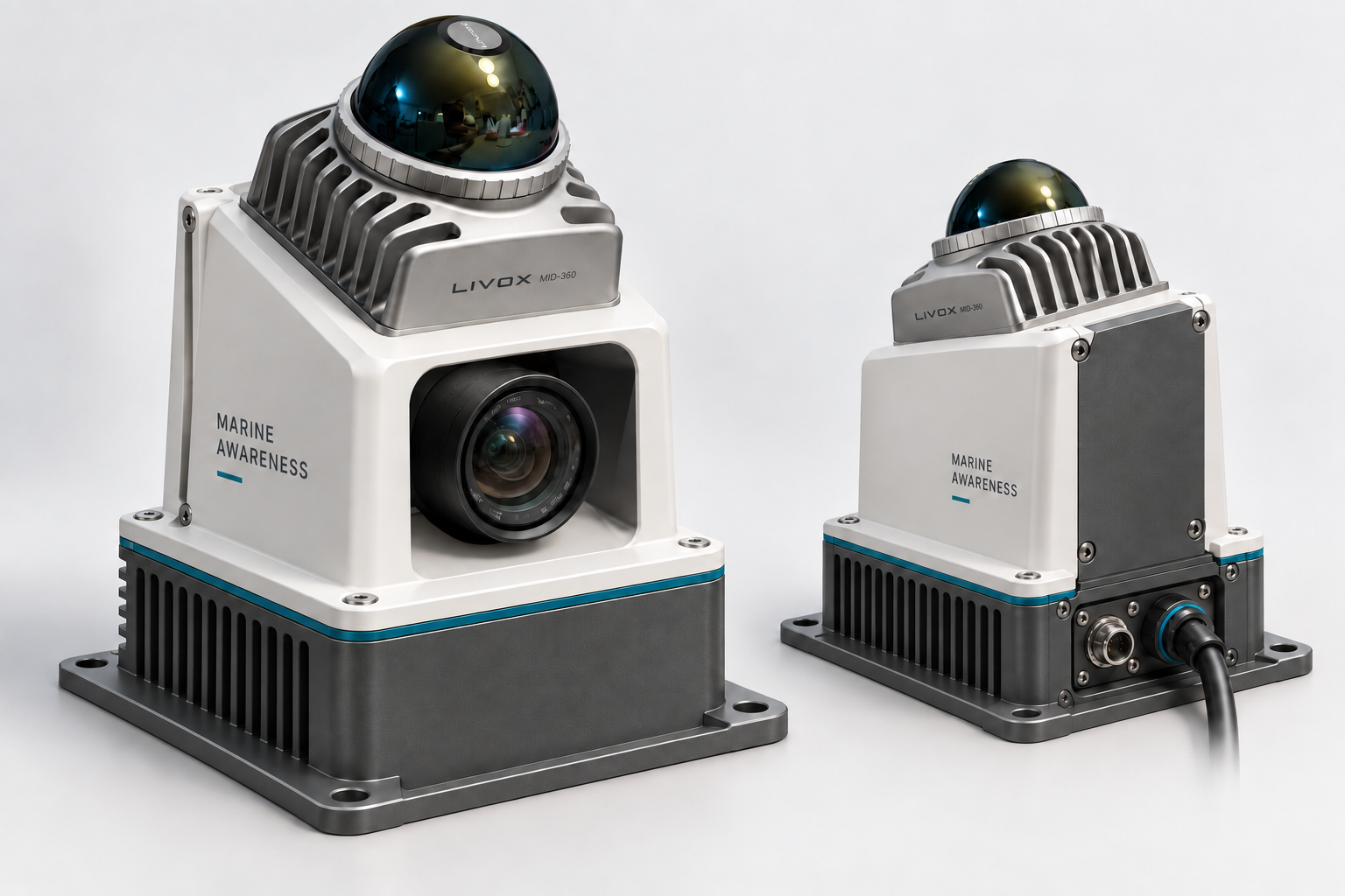
Marine Awareness enclosure concept in front and rear views, with a wide charcoal computer base below a narrower white camera housing and exposed Livox LiDARView enclosure concept

Product design · proposed enclosure

An onboard enclosure, taking shape.

A proposed housing for the working sensor rig, with a wider computer base, a recessed camera and rear connections. The design direction brings mounting, cable routing and service access into one unit.

Start with your operating situation

Where would a clearer view help your operator?

Alongside a quay, inside a lock or operating from shore: choose one inland waterway manoeuvre where additional distance information could help. These are proposed pilot scenarios; we agree the useful information and evidence with your team.

01Fleet operators & skippers

Docking beside a quay

How much room remains on this side?

During the final approach, the quay edge or a nearby moored vessel can be difficult to judge from the helm or a remote camera view.

What could help
A camera view with supported distance cues and a clearly defined area to monitor.
What your pilot should prove
Compare displayed distances with reference measurements, account for the hull and mounting position, and assess whether proximity cues arrive in time to be useful.
Proposed first pilot
02Urban waterway & workboat operators

Entering a lock or narrow berth

What is close along the side of the vessel?

Walls, fenders, posts and other vessels create a changing close-range scene as the vessel enters a confined space.

What could help
A view of visible surfaces with distance context, even where an object has no useful AI label.
What your pilot should prove
Establish which areas the installation sees, where blind areas remain and how readings behave during a slow manoeuvre.
Proposed pilot scenario
03Survey teams & waterway managers

Surveying near structures

Can we review the close manoeuvre as well as the survey?

A survey run near bridge supports, jetties or quay walls requires the crew to manage the vessel’s immediate surroundings alongside the survey task.

What could help
Local scene information and recorded sensor data to review an approach or explain an interrupted run.
What your pilot should prove
Confirm that observations and logs can be related to the manoeuvre and that the display fits the crew’s existing workflow.
Proposed pilot scenario
04Remote-operation providers & vessel integrators

Manoeuvring from a shore control centre

How close are we to the quay, and is that reading current?

During berthing or lock entry, an operator ashore interprets cameras alongside existing navigation and vessel data. A measured view of nearby surfaces could add context for the final approach.

What could help
Evaluate onboard distance observations, proximity events and visible data age within your existing operator workflow. Agree which information deserves attention and how unavailable readings should appear.
What your pilot should prove
Compare the existing operator view with the added observations during one controlled manoeuvre. Check hull clearance, missed and nuisance alerts, end-to-end delay and stale-data behaviour. Interface design and remote delivery remain future work.
Integration pilot to scope

See what exists today

See the information behind the idea.

Four views from the working indoor prototype: nearby surfaces, a proximity indication, object context and the complete system. Each shows something different that a vessel pilot can evaluate.

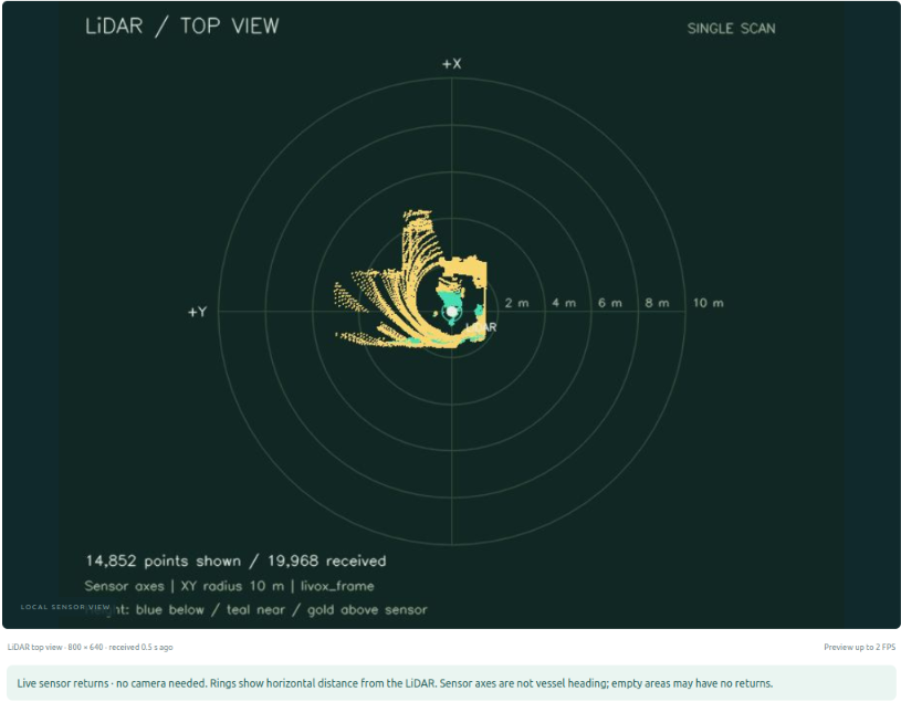
The dashboard’s separate LiDAR view shows an indoor point cloud around the sensor, horizontal distance rings and a note that sensor axes are not vessel heading
Enlarge image
01 / Nearby surfaces · 21 September 2026

See nearby surfaces from above.

Enlarged detail · separate LiDAR view

The dedicated LiDAR view displays surface returns around the sensor. Distance rings make the arrangement easier to inspect, without requiring an AI object label.

Why it matters onboard or ashore

For a quay, lock wall or post, the useful question is where the surface is. This view provides a way to evaluate that geometry with an operator onboard or ashore.

Indoor sensor view. Rings show distance from the LiDAR, not hull clearance. Blank areas do not establish free space; mounting and coverage need vessel checks.

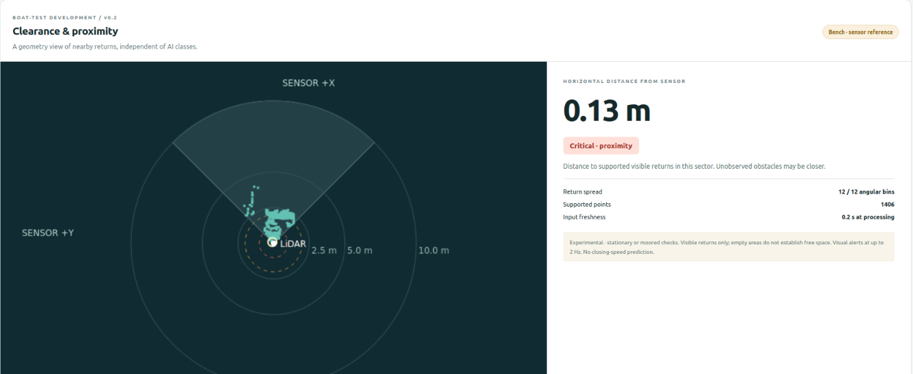
The indoor proximity panel displays a monitored sector, a 0.13 metre sensor-reference reading, a Critical proximity state, supporting points and input freshness
Enlarge image
02 / Proximity display · 21 September 2026

Bring a close return to the operator’s attention.

Enlarged detail · proximity panel

The panel combines the monitored area with a proximity state, supporting-point information and input freshness. It presents geometry independently of the camera’s object labels.

Why it matters onboard or ashore

During docking or lock entry, an operator needs to know which area deserves attention and whether the information is current. This is the display concept to evaluate in a controlled pilot.

The displayed 0.13 m is an unverified indoor sensor-reference reading. This capture shows the interface operating; it does not establish range accuracy, hull clearance or reliable warning behaviour.

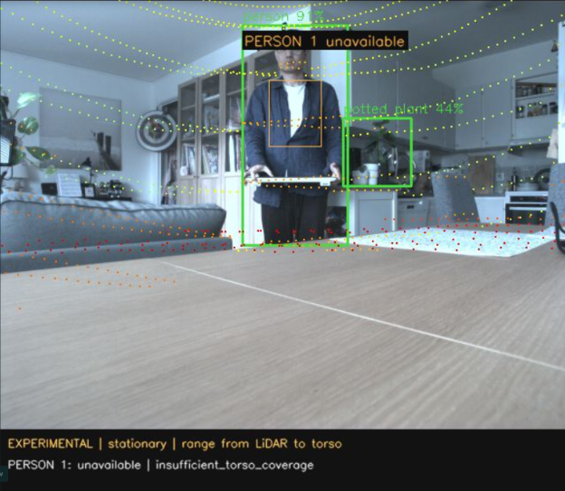
Indoor camera image with AI detection boxes and projected LiDAR points; the person range is unavailable because torso coverage is insufficient
Enlarge image
03 / Object context · 18 September 2026

See the scene and the measurements together.

Enlarged detail · camera and LiDAR overlay

The camera image, detected objects and LiDAR points share one view. An operator can inspect the scene alongside the measurements behind it.

Why it matters onboard or ashore

Whether this combination of views could help your crew understand nearby objects and structures.

Indoor integration evidence. The range is unavailable in this frame because coverage was insufficient; this image does not establish distance accuracy.

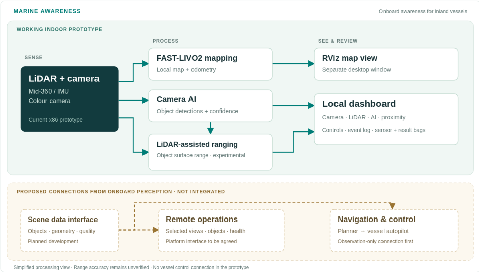
The dashboard’s system overview links sensing, mapping, AI and experimental ranging to operator views, with proposed remote-operation and navigation connections shown as dashed lines
Enlarge image
04 / System overview · 21 September 2026

Understand how it could fit your operation.

Enlarged detail · system overview

The dashboard’s overview shows how the sensor rig supports mapping, object information and experimental ranging, and where future interfaces would connect.

Why it matters onboard or ashore

The role of onboard awareness within your wider navigation, survey or remote-operation setup.

Dashed connections are proposed and not integrated. There is no vessel-control connection in the current prototype.

Cropped from real indoor screenshots, with readings and status labels unchanged. These are recorded views, not a live vessel feed. The older demonstration shows person ranging; development now includes broader object and geometric proximity awareness.

Information for the person operating the vessel

One scene. Different questions answered.

Start with the information you need. Explore what the current prototype can show and what remains to be validated for your vessel.

Your question

What am I looking at?

Demonstrated indoors

Keep the surroundings in view.

Inspect the camera image alongside the sensor information, so a measurement has a visible point of reference.

Why it could help

Relate a reported object or surface to what the operator can actually see.

How it worksLive camera view

The same camera stream feeds the operator display and perception software.

The camera’s direction, lighting and obstructions determine what is visible.

How it fits onboard

From nearby surfaces to an operator view.

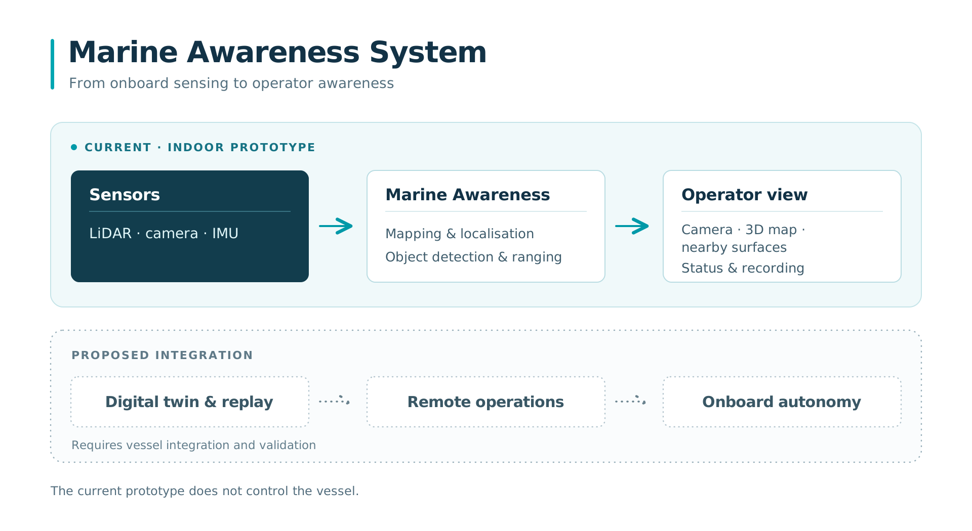
Current indoor prototype: LiDAR, camera and IMU feed Marine Awareness mapping, detection and ranging, then the operator view and recording. Proposed next integrations: digital twin and replay, remote operations and onboard autonomy. The current prototype does not control the vessel.
Open full-size diagramExplore the integration roadmap

Alongside NaviDepth or on an existing vessel. NaviDepth builds knowledge of the waterway. Marine Awareness focuses on nearby surfaces and objects during vessel operations.

Set clear expectations

What you can see today. What comes next.

A pilot should answer an operating question with evidence. These stages separate the demonstrated foundation from the work still needed.

Today · demonstrated indoors

Inspect the prototype

Camera, LiDAR, mapping, AI detections and experimental stationary ranges are brought together through the local dashboard. The latest capture also shows the proximity display operating indoors.

Your next conversation

Which views would be useful during your chosen manoeuvre?

Next · verify the proximity MVP

Check useful distance cues

Verify the new monitoring-sector, threshold and event-log functions against reference measurements. Establish coverage and timing in the intended setup.

Evidence to produce

Repeatable measurements, clear unavailable states and useful warning behaviour.

Then · a controlled vessel pilot

Evaluate it in your operation

Start with moored checks. Review those results before a supervised low-speed observation test with normal vessel control retained.

Your decision

Does the information help, and what would be required for the next installation?

Current scope: operator awareness and experimental proximity cues. Vessel performance and benefits remain to be validated. Automatic collision avoidance and autonomous vessel control are outside the present prototype. The digital-twin and remote-operation resilience concept adds a proposed integration path, with onboard autonomy as a further development and validation stage.

Explore the digital twin and resilience development path

Content reviewed

Make the evaluation useful to your team

Your vessel. One task. Agreed evidence.

Start with one recurring manoeuvre or visibility problem. We define the observation, installation and test conditions with your team.

  1. 01

    Choose the task

    Identify the vessel, operating area, operator and the moment when better nearby information would help.

  2. 02

    Agree the installation and checks

    Confirm mounting, power, viewing direction and vessel dimensions. Check known distances before going afloat.

  3. 03

    Observe under controlled conditions

    Begin moored. Progress to low-speed observation only after reviewing coverage, latency and motion effects. The skipper retains control.

  4. 04

    Review a practical result

    Compare sensor outputs with reference measurements and operator feedback. Decide what to improve, integrate or test next.

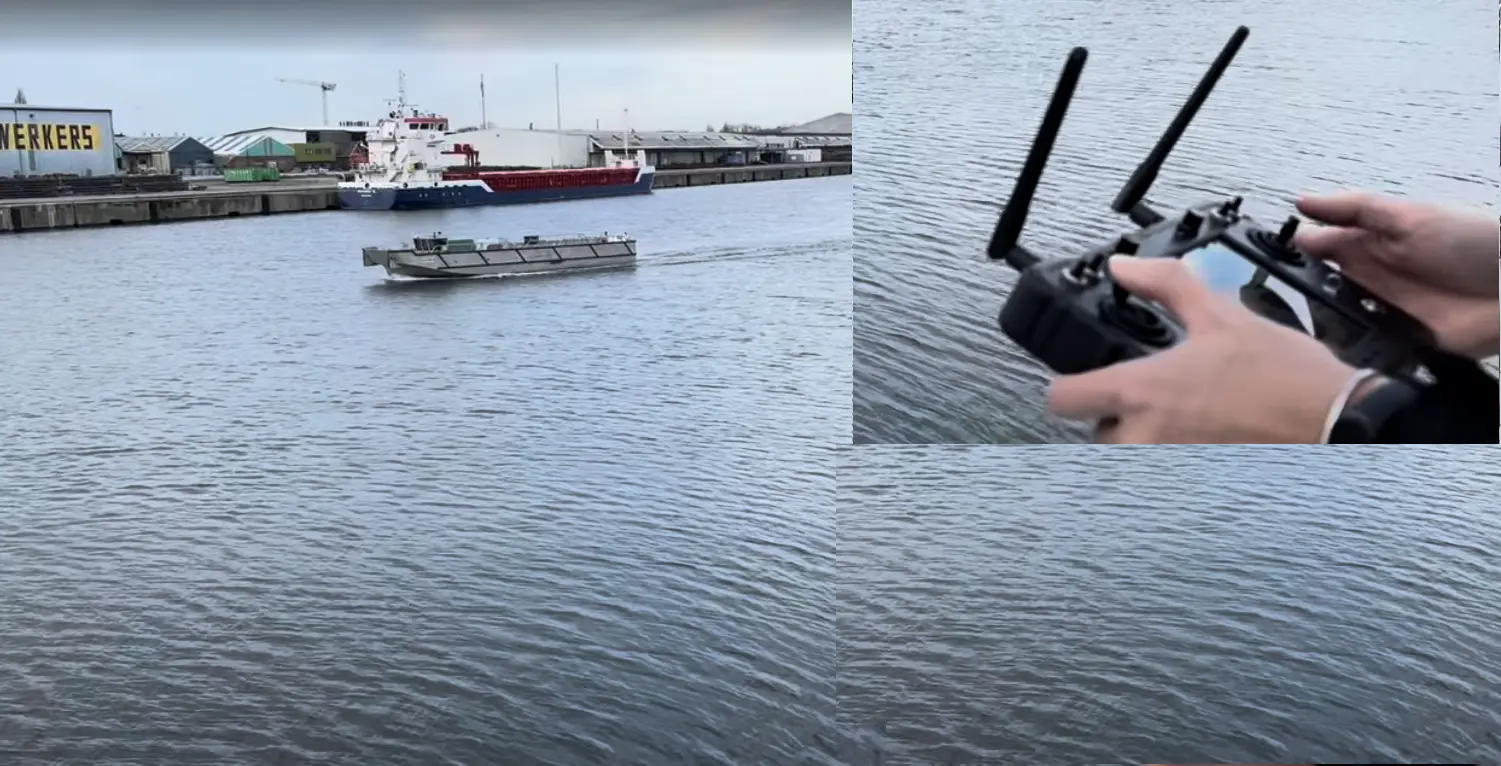
AVATAR vessel and handheld controller from UWL’s existing vessel work
AVATAR project context. This is existing vessel work; a Marine Awareness vessel trial has not yet been demonstrated.
What a pilot should leave you with

A decision supported by evidence.

An account of the observed coverage, measurement behaviour, operator usefulness and remaining integration work.

Vessel applications & pilot coordinationUrban Waterway Logistics (UWL)

Operating requirements and proposed vessel pilots

Perception development & integrationMarine RoboTech

Sensor integration, software and prototype evaluation

Pilot roles, deliverables and test objectives are agreed with the vessel operator before work begins.

Discuss your operating situation

Where would better nearby information help?

Tell us about one manoeuvre, the view available to the operator and the information that is missing. We can discuss whether a focused Marine Awareness pilot is a useful next step.

Discuss your vessel and use caseContact Marine RoboTech to discuss technical requirements and integration. Vessel access, operating responsibilities and pilot scope are agreed with the operating partner.